
Mobile app to enable satellite image classification on mobile devices in the context of the Missing Maps Project which proactively maps the places in the world where the most vulnerable people live before a crisis happens.
Tools and Features
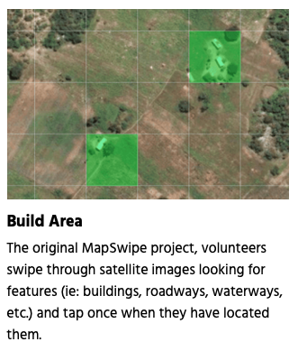
- in the mobile app users swipe through satellite imagery tapping the features they spot
- marked tiles will become the base layer of detailed maps drawn by other volunteers
- high-quality geographical data that is freely accessible and available to everyone
Governance of Case
The Missing Maps Project is an open collaboration founded by the American Red Cross, the British Red Cross, Humanitarian OSM Team (HOT) and Medecins Sans Frontieres/Doctors Without Borders (MSF). MapSwipe was built with a financial and HR investment by MSF UK and the efforts of passionate humanitarian volunteers.
Drivers for Open Mobility
MapSwipe is an open source project created and maintained by volunteers for collaborative mapping in CC using second level crowdsourcing (user generated data)